Thursday, 9 January 2014

Loch Shieldaig, Wester Ross

Strolling along the shore in front of the main street in Shieldaig village I found several large scallop shells, open and discarded and now half hidden among the boulders and seaweed strewn along the shoreline. Diving for scallops is common is these parts as is creeling for shellfish, but today's fishing is far removed from the industry which grew up here during the 1800's. Then the area was renowned for its herring and the name Shieldaig actually comes from the old Norse meaning Herring Bay.

View from the Applecross Road towards the village of Shiledaig


Shieldaig village was built with grants from the Admiralty who were keen to train seamen to join the Royal Navy during the Napoleonic Wars. The villagers, however, were never called on to fight as Napoleon was defeated at Waterloo in 1815 after which the Admiralty pull their funding from the area and the villagers were forced to return to herring fishing.

The whitewashed houses of Shieldaig's main street


The herring may now be gone but fishing today is as vibrant as ever and concentrates on prawns, nephrops, langoustines and lobsters, mussels and salmon. Spurred on by a love of all things fishy we sought out the Loch Torridon smoke house which is situated in a small garden just off the main street in Shieldaig. All the products here are local and oak smoked and if you love fish it is well worth a visit.

Shiledaig village is a picturesque place with its string of whitewashed houses lining the shore. Probably the best known feature here is Shiledaig Island which sits just offshore from the village. It is a curious rocky mound covered in Caledonian Pine trees and is now owned by the National Trust for Scotland and run as a bird reserve. In recent years it has proved attractive as a nest site for a pair of white tailed sea eagles which have bred here successfully several times.

Shieldaig Island


 To the north of the village is a rocky proprietary which separates Loch Shiledaig from its larger neighbour Loch Torridon. There is a lovely walk which follows the edge of the peninsular and affords fantastic views along the shores of both Loch Torridon and Shieldaig. Following a well worn path we came across two wonderfully isolated cottages,with no route back to civilisation except by sea or on foot. I couldn't help thinking how magical and inspiring this must be; the ultimate retreat for an artist. I suspect the reality however would be much harder than my daydreams suggest.

My idea of an artists retreat!

Looking out over Loch Torridon


Returning to the village we seek out refreshments in Nanny's; a  tearoom and craft shop at the far end of the street. This delightful little building houses an Aladdin's cave of crafts, books and pictures including many stunning images from local photographer Steve Carter.

View from the Applecross Road


Loch Shieldaig Facts

OS Explorer Map 428
Steve Carter also runs a comprehensive website about Torridon and Shiledaig which contains some really useful information if you are planning a visit.


Wednesday, 8 January 2014

Loch Torridon and Upper Loch Torridon

The beauty of the Scottish Highlands especially for a photographer is that you can visit the same place time after time and it will always look different. No matter what the season or the weather conditions the light and the way it embraces the landscape is the principal factor that ensures each visit is a unique experience.

I first came across Loch Torridon a couple of winters ago when I was visiting Applecross. Snow laid heavy on the land as I made my journey along the coast road. The bright white covering helped define the edges of the loch and softened the usually stark monolithic peaks which surround it. The days then were still and bright and unbelievably cold but they were also inspiring and life affirming. Standing at the viewpoint on the A896 looking out over the vast expanse of Upper Loch Torridon and drinking in the amazing view it felt good to be alive.

View across Upper Loch Torridon

I found myself back on the shores of Loch Torridon just over a year later, this time in the summer when the landscape was greener and softer but no less dramatic. I had chosen to stay in the little village of Arrina (or Arinacrinachd as it is sometimes called) on the western shore between Fearnbeg and Kenmore. My home for the duration of my stay was the Old Post Office; a  traditional building with dormer windows and a stunning view over the loch. As its name suggests the building once served as the post office and shop for the whole area; a role it maintained until the 1950's when the whole crofting way of life began to decline and the coastal villages were largely abandoned. It wasn't until the new coast road was built in the 1970's that this process was reversed.

The name Arinacrinachd comes from the Gaelic and means "The Shieling of the Picts". A shieling is a summer pasture and the Picts were a late Iron Age and Early Medieval Celtic people. At the far side of the hill behind the village we found an ancient standing stone, a mysterious relic from times long past, it stood alone and uncluttered in a grassy field surrounded by sheep.

View from the Old Post Office towards Loch Torridon


Looking across the fields towards the loch


Sunset over Loch Torridon


The village of Torridon lies at the head of Upper Loch Torridon. It is dwarfed by the towering peaks of Liathach, Beinn Alligin and Beinn Eighe all of which are over 3000 feet high and are composed of some of the oldest rocks found anywhere in Britain. In summer Torridon is a popular place with walkers and although it can never be described as busy by southern standards it definitely feels less remote at this time of year. If you are interested in the areas wildlife it is worth checking out the Torridon Countryside Centre which stands at the foot of Glen Torridon. We also took time out for refreshments in the Torridon Stores and Cafe which was quite busy but worth the stop.

This year I was back in Torridon again; another winter visit but only a scattering of snow this time. Despite the frequent wet weather this is my favourite time of year by the loch. A sense of  peace pervades and the remoteness feels more intense. It is always possible to feel alone here in this vast expanse of wilderness,but never lonely as there is always so much to see; divers on the loch, deer on the mountains and always a great photographic opportunity just around the corner.


Loch Torridon Facts

OS Explorer Map 428
Loch Torridon is around 15 miles long and was formed by glaciation.
There are several islands within the loch which are:
            in Upper Loch Torridon: Eilean à Chaoil, Eilean Cnapach, both of which are tidal.
            in outer Loch Torridon: Eilean Mòr, Eilean Tioram, Sgeir Ghlas, Sgeir na Trian.

Tuesday, 7 January 2014

Loch Carron, Wester Ross

Standing at the viewpoint on the A890 just outside Strome Ferry it is possible to get a feel for the sheer magnificence of Loch Carron and the mountains which surround it. This is highland scenery at its very best; grand in scale but subtle in detail, a mixture of forest, moorland, mountain and loch.

I had chosen a beautiful day for my first glimpse of  Loch Carron, a still afternoon without a breath of wind, conditions which allowed the varied colours of the landscape to bleed into the water creating perfect reflections. The pale blue winter sky and the depth of the water only added to the intensity of the scene.

View from the A890 looking towards the village of Lochcarron


The River Carron runs through Glen Carron and feeds into the loch at its east end near Strathcarron. The village of Loch Carron lies on the northwest shore; a pretty string of traditional white highland houses, shops and cafes. At two miles from one end to the other this linear village is said to be one of the longest in Scotland. Despite its size (quite large by highland village standards) it is a tranquil place and well worth taking some time to wander around. We found a delightful bistro (the Lochcarron Bistro) along the front serving delicious local mussels one of many mouthwatering dishes on their menu.

Houses on the Lochcarron shoreline


The loch is picturesque in any weather and at any time of the year but winter snow adds an extra dimension to the landscape and the warming colours present at the end of the short winter days are ideal for photography.

Winter at Lochcarron


At the mouth of the loch where the waters meet the sea lies the little village of Plockton. Noted for its unusual palm fringed shoreline (not something you would expect to find in the highlands) this picturesque village is a popular destination for artists.  Some of the houses date back to the 18th century when the village was a busy fishing community. Strung out along the shore line the mixture of white and stone cottages face the loch, separated from their gardens and the shore by the quiet village road. Even in the height of winter these gardens look more tropical than highland with their palm trees swaying in the gentle afternoon breeze.

Plockton waterfront


One of the sheltered bays along the Plockton waterfront


At one end of the village is a little slipway allowing access to the sheltered harbour while at the other end the main pier is the departure point for the summer seal trips which run regularly along the loch.

The Slipway


The main street lies on a small inlet sheltered from the prevailing winds by a peninsular of high ground. It is well worth seeking out the walk which climbs steeply over rocky, boggy ground dotted with rhododendron bushes before eventually reaching the plateau at the back of the village. From here there are stunning views across the mouth of the loch to the mountains beyond. This is an easy place to while away a few hours and although the vantage point is not high by Highland standards it is still possible to feel on top of the world thanks to the stunning views and the wonders of this wild landscape.

View from above Plockton looking out over Loch Carron


Loch Carron Facts

OS Explorer Maps 428 and 429
In places Loch Carron is over 100 metres  deep
Loch Carron lies between the Torridon and Kintail mountain ranges


Wednesday, 1 January 2014

Loch Shieldaig, off Gair Loch, Wester Ross

This beautiful, picturesque but tiny loch is situated along the road to Red Point. It is actually a small branch of Gair Loch but is shielded from the main water by Eilean Shieldaig a small rocky island in the centre of the loch.
Loch Shieldaig and Eilean Shieldaig


At the head of the loch lies an impressive Victorian red sandstone building which was originally a hunting lodge but is now better known as the Shieldaig Lodge Hotel. In the winter the loch is quiet; a few dinghies bob on their moorings, and a sailing boat sits on the beach in front of the hotel, but summer time is different and then the little loch is alive with boats.


The difference in height between high and low water here is 6 meters. At high tide the water reaches the edges of the road walls and there is not much evidence of any shoreline, but when it retreats it reveals beaches of black and grey boulders covered in ochre coloured seaweeds. Herons fish from the shores whilst cormorants try their luck from the centre of the loch.

Cross the road by the hotel and you will find a stream flowing down the rocky slope, under a bridge and into the loch. Trees covered in rich green cloaks of moss and lichens edge the tumbling waterway. These are some of my favourite features of this part of Scotland; bare winter trees in their green mantles products of the pure highland atmosphere.

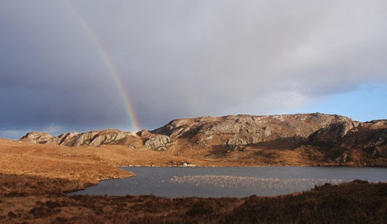
The hills behind Loch Shiledaig hide the magically named fairy lochs which are notable for their beauty as well as being the crash site of a WWII American Liberator bomber. A memorial to the crew and some wreckage are a permanent reminder of what happened here on 13th June 1945. There are some good circular walks from Loch Shieldaig to the Fairy Lochs.

A rainbow over the Fairy Lochs


Loch Shieldaig Facts

OS Explorer Map 434

Monday, 30 December 2013

Gair Loch (Loch Gairloch), Wester Ross

I had never heard of Dry Island before this winter despite having visited the Gair Loch area several times over the last 5 years. It is situated just outside Badachro and is a rare example of an old fishing and curing station which once played an important part in the fishing history of the loch. Connected to the mainland by a long wooden causeway which floats at high tide the island is a tranquil spot owned by the McWhinney family who run holiday cottages and shell fish safaris from its shores.

Dry Island


Dry Island is in fact only an island at high tide; at low water it is joined to the mainland by a sea of mud. It is accessible at all times by a long wooden floating causeway which links the island to the mainland. This rocky outcrop sits in an enviable location in Badachro Bay, its steeps sides rising up from the sheltered waters. The boulder strewn shoreline is covered in ochre coloured seaweed and attracts herons and cormorants who come to fish in the shallows.

Badachro Bay


There are several small rocky islands in this part of Gair Loch but only one other, Eilean Horrisdale is inhabited.

View from one of the self catering cottages on Dry Island


Gair Loch comes from the Gaelic meaning the short loch; at roughly 6 miles long and 1.5 miles wide it flows into the Little Minch. At the heart of the loch is the village which takes its name. Gairloch has a range of small shops, a really interesting tearoom and bookshop that is especially appealing if you love the great outdoors, a heritage museum and some lovely sandy beaches.

Harbour Porpoise in Gair Loch
The harbour at Charleston is situated a little way out from the main village but is well worth a visit. In the summer the quayside is alive with visitors who flock here to take one of the many boat trips available on the loch. Due to the warming waters of the gulf stream the area is a haven for wildlife and the trips offer the opportunity to see whales, dolphins, otters, and harbour porpoises as well as many species of birds.

In the woods behind the harbour lie the Flowerdale waterfalls which can be reached by a lovely walk along the river. They are probably best viewed after heavy rain but the walk is very scenic whatever the weather.

Rua Reidh Lighthouse
From Gairloch the road runs north though the tiny villages of Strath, North Erradale, and Melvaig until it reaches the lighthouse at the end of the peninsular. This road is one of the so called "Destitution Roads" which are faily common in the area. They were built and part funded by a scheme set up to help ease poverty caused by the potato famine  in the 19th century.

At the end of the road is the Rua Reidh lighthouse which is reached by a private track. We drove along this following advice in a local tourist guide and followed a route that gave some of the best coastal views in Wester Ross.
Since writing this I have received a rather terse email from the owners asking me to remove all references to access by car and would like to make it clear that access is from Melvaig by foot only. There are many references in many guides to a visitors centre but these should now be ignored as it no longer exists. See wikipedia for more


Gair Loch facts

OS Explorer Map 434
Gairloch has its own boat club with an active sailing scene

Loch Reraig, Wester Ross

Loch is really a grand name for this little indent at the edge of Loch Carron, for large it is not. However what it lacks in volume it more than makes up for visually. From the head of the loch it is possible to look out over the isles of Skye, Scalpay and Rassay which form a magnificent backdrop to the still waters within.
Ardaneaskan and the end of the road
Wooded banks stretch down to the waters edge and there are some lovely walks over the surrounding hills. At low water the tide retreats to reveal a large expanse of rock and dark sand.

To access the loch we traveled the single track road running along the edge of Loch Carron and parked in the shoreside village of Ardaneaskan. This linear settlement is best known for its tiny crofting museum which comprises a single room in an old stone building. The road peters out just past the museum where a small carpark can be found on the left. From here a track heads off downhill towards the loch skirting the edge of the pine woodland.

Looking out towards Skye

At the head of the loch we came across the clear, cool waters of Reraig Burn running across marshy ground before tumbling over rocks and boulders to get to the sea beyond. As with many places in the Highlands we had the whole loch to ourselves and the peace and quiet was fabulous.

Loch Reraig Facts

OS Explorer Map 428
At the end of the road is the Ardaneaskan Museum; probably one of the smallest in the country it contains items which formed part of a crofters everyday life.

Sunday, 29 December 2013

Loch Kishorn, Wester Ross

Winter is one of my favourite times to be in Scotland. With a covering of snow and constantly changing light it is a rich environment for a photographer and one that I am happy to explore on a regular basis.

Loch Kishorn is situated in one of my favourite parts of the West Coast on the edge of the Applecross peninsular. The loch looks across some of the most wild and rugged landscapes on this part of the coast, but it does not feel barren or isolated.

Loch Kishorn at sunrise
There are three small settlements strung out along the eastern shore of the loch. Collectively know as Kishorn. they are in fact the villages of Sanachan, Ardarroch  and Achintraid. Sanachan lies at the head of the loch on the main road and contains all the amenities incluiding a shop and post office and a small chapel. Ardarroch and Achintraid lie further off the main road and are much quieter; they also have the best views looking out over the Corbetts of Sgurr a' Chaorachain and Beinn Bhàn and the pass of the Bealach na Ba.

View over Loch Kishorn from the Bealach na Ba
If you only do one thing on a trip to this area it should be to take the Bealach na Ba, the ancient drovers route to Applecross also known as the pass of the cattle. This breathtaking single track road has hairpin bends and 1 in 4 slopes and boasts the greatest ascent of any road climb in the UK, rising from sea level to 626 metres. The assent is both hair raising and awe inspiring at any time of the year but in the snow it is even more spectacular and the views looking back over loch Kishorn are stunning.

The Garra Islands at the mouth of Loch Kishorn
The eastern slopes of the loch are softened by large areas of forest with paths and trails running in all directions. There is a lovely walk out to the mouth of the loch giving views over the Garra Islands which mark the entrance; the largest if which is Kishorn Island.

Aquaculture is an important industry in this part of the Highlands and as you walk out of Achintraid towards the sea you pass several large fish farms producing large quantities of Atlantic Salmon. The villages link with the sea and seafood is further illustrated by the award winning
Kishorn Seafood bar which is situated on the main road near the head of the loch.

Achintraid
Loch Kishorn is fed by the Kishorn river which flows down from the north and tumbles over a boulder strew riverbed into the loch. Cross the river and follow the road a little way and the remains of the Kishorn Yard, a fabrication plant for oil platforms can be seen.. The yard operated from 1975 to 1987 and at its peak employed over 3,000 people housed in temporary accommodation on site and in two ships in the loch. It is hard to imagine this tranquil place having such large scale industry at its heart for much of the evidence has now vanished to be reclaimed once again by the wild.

Looking across the Loch from Achintraid

Loch Kishorn facts

OS Explorer Map 428
Loch Kishorn is approximately 4 miles long from the head of the estuary to the sea and 1 mile wide. 
It has a maximum depth of 61 meters and is actually a fjord.