Showing posts with label Estuaries. Show all posts

Saturday, 8 March 2014

The Colne Estuary, Essex

Wivenhoe, a small and characterful town popular with artists seemed a good place to begin my exploration of the Colne Estuary. It is home to one of my favourite marine artists, James Dodds, who has beautifully captured the essence of this riverside town in his linocut "Wivenhoe past and present". Complex in detail this image portrays the relationship between the town and the estuary and illustrates the reliance on the waterway that has grown and developed over many centuries.

Wivenhoe lies on the east shore of the estuary about 3 miles south east of Colchester where it developed as a port for its larger neighbour. The town was recorded in the Domesday book of 1086 but really established it's significance with the growth of its fishing and shipbuilding industries. In the 18th Century the towns upstream shipyard built a succession of fishing smacks and cargo vessels, a ropery flourished and the fishing fleet landed sprats and oysters. By the end of the 19th century a dry dock had been build and commercial vessels constructed from riveted metal plate were the order of the day. Unfortunately after the war the shipbuilding industry went into decline and the yards at Wivenhoe eventually closed in 1992.

Today Wivenhoe is a picturesque waterside town, a successful blend of traditional architecture and modern waterside living.
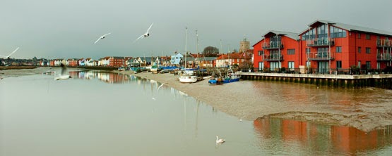
Wivenhoe Waterfront


The waterfront is full of character and colour and it is easy to see why this place has become so popular with the artistic community. Sailing boats and fishing vessels line the waterfront watched over by a mixture of quaint old buildings and modern apartments. There is an air of affluence here among the modern waterfront which contrasts nicely with the muddy estuary and the more rustic shoreline.

Wivenhoe


Half way along the front is the Nottage Maritime Museum a fantastic place for learning about boat-building and nautical skills. It also houses an amazing collection of memorabilia relating to the River Colne and is open on most Sundays during the summer months.

As you stroll further along the shoreline you eventually reach the Colne tidal barrier which was built in 1993 to protect the town and surrounding land from tidal and storm surge flooding. It is a huge concrete and steel structure and looks imposing and out of place in its surroundings. Beyond the barrier lies Wivenhoe Sailing Club and an estuary that immediately becomes wild and unoccupied.

Colne Estuary from Wivenhoe Sailing Club


From Wivenhoe the Colne flows through muddy banks alive with the sound of waders, twisting and turning on its journey to the coast.

The bustling town of Brightlingsea lies at the mouth of the Colne Estuary on the junction with Brightlingsea Creek. Although not a large settlement the town has an importance as a port which goes back to the eleven hundreds when the Confederation of Cinque Ports was established. This consisted of 5 towns along the South Coast and 23 connected towns and villages known as" limbs" and Brightlingsea became a limb for the Cinque Port of Sandwich. The Cinque ports were originally formed for military and trade purposes however their significance today is purely ceremonial.

Brightlingsea is a happy place full of activity. It is a town which delights in its connections with the water and the estuary that it sits along side. There is a strong watersports scene here with two sailing clubs and a rowing club situated along the waterfront and a multitude of water based businesses around the town.

Brightlingsea Waterfront


The main harbour lies opposite the town centre and is a hub of activity. To the left of the Colne sailing club is the Aldous Heritage Smack Dock; a site acquired for the preservation and conservation of these graceful working boats.

At the far end of town the promenade, backed by a row of colourful beach huts, leads out to Batemans tower a folly built in 1883. From its position at the mouth of the estuary it is possible to see right across to Stone point in one direction and Mersea Island in the other.

Batemans Tower


Batemans Tower


Colne Estuary Facts

OS Explorer map 184

The Colne Estuary is an important habitat for wildlife and is one of the most protected areas on the East Coast. It comprises a variety of different habitats including:
Tidal mud flats 30%
Salt marshes 25%
Freshwater marshes 20%
Estuarine waters 19%
Sand / shingle shores (including dune systems) 3%
Coastal brackish / saline lagoons 2%
Marine beds (e.g. sea grass beds) 1%

The Colne estuary is an SSSI
Brightlingsea Marshes, East Mersea and Colne Point form part of the Colne Estuary National Nature Reserve.
Colne Point, Fingringhoe Wick and Howlands Marsh are owned and managed as nature reserves by the Essex Wildlife Trust.



Sunday, 2 February 2014

Oulton Broad (Lake Lothing and the River Waveney), Suffolk

Standing on the bridge over Mutford Lock it is possible to look over two very different bodies of water. To the West lies Oulton Broad a vast expanse of fresh water leading to the River Waveney and the Broads whilst to the East lies Lake Lothing a salt water lake busy with shipping and seemingly overwhelmed by heavy industry. Mutford Lock forms the dividing line between these two very different worlds and provides a gateway from one to the other.

Technically Oulton Broad and Lake Lothing are not estuaries and are actually man made features but I have included them because they provide an important and well used access point to the Broads National Park; the UK's largest wetland habitat.

Mutford Lock is a busy place, both on and off the water. The A1117 carries traffic over the bridge whilst pleasure boats traveling to and from the Broads keep the lock in regular use. We strolled around the edge of the Broad from the Wherry Hotel to Nicholas Everitt park. Not exactly peaceful as we never escaped the road noise, but pleasant enough, our entertainment provided by a huge flock of greylag geese keeping busy on the wind blown choppy waters of the Broad.

Mutford Lock, Oulton Broad


Oulton Broad


There is something about parts of the Broads that never feel natural to me, and maybe that is partly due to its man made origins, but also I think it has taken on a theme park feel in places and has somehow lost its wild side. That is not to say that nature is not abundant here, because it is, it's just for me it seems too managed and artificial.

Crossing the road over Mutford Lock and wandering along the shores of Lake Lothing the area feels more raw, much less pretty but somehow more real. Gone are the flocks of geese so domestic in their appearance replaced by more typical estuarine species. Comical turnstones hurrying about their business on the wooden pontoons and a cormorant drying his wings on a post in the sunshine. It felt to me that by just crossing the lock from Oulton Broad to Lake Lothing the wild had returned.

Lake Lothing


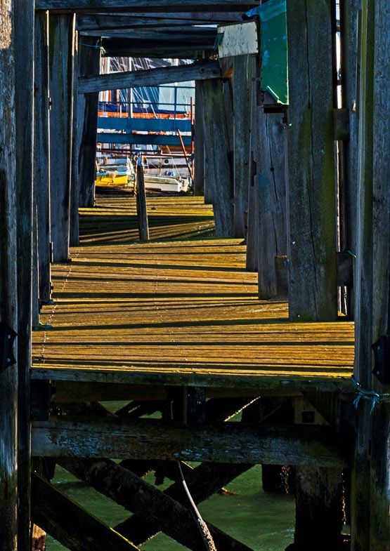
Lake Lothing is industrial, there is no getting away from it. The shore is dotted with boatyards and boat builders, engineering works and industrial buildings and the water is full of fishing vessels and working boats. There is a general air of chaos everywhere and decay in places but despite this the place has a certain charm.

Rickety jetty, Lake Lothing
Lake Lothing continues east from Mutford Lock to Lowestoft where it flows out into the North Sea.

Today Lowestoft is  typical of many seaside towns suffering its fair share of decline and hard times. For despite its long sandy beaches its fortunes have not always been rosy.

The town grew up around the herring fishing industry in the 1800's. In 1830 the harbour was constructed allowing easy access for the herring drifters which worked the East Coast for most of the 19th Century.

The herring fishing industry went into decline at the start of the first world war when stocks began to decline and  most of the fishing fleet was seconded by the Royal Navy. Today Lowestoft still relies on the sea to boost its economy, although now it is the oil gas and wind farms which are the biggest offshore employers.

The town has grown up on either side of the harbour. On the south is the marina, the Royal Norfolk and Suffolk Yacht Club and the RNLI station, whilst the north side is more industrial with moorings for the wind farm catamarans and large shipping.

Lowestoft Harbour


Lowestoft Harbour


Lake Lothing runs out to  meet the North Sea through a narrow harbour entrance flanked by two pagoda type lighthouses, a rather utilitarian entrance in keeping with the waters industrial feel.

Harbour entrance and the North Sea


Lake Lothing and Oulton Broad facts

OS Explorer Map OL40
Imray Chart 2000-10
Sailing Clubs;
Royal Norfolk and Suffolk Yacht Club at Lowestoft
Waveney and Oulton Broad Yacht Club

Tuesday, 14 January 2014

The Stour Estuary, Suffolk

As I strolled along the banks of Holbrook Creek enjoying the weak winter sunshine I noticed something moving on the gravel at the waters edge. At first glance it looked as if the beach was alive, twisting and turning and running from the encroaching tide, but on closer inspection I discovered a flock of Turnstones hurriedly pacing up and down at the waters edge flicking pebbles and bits of seaweed in all directions .

Turnstones at Holbrook Creek
These comical little birds are some of my favourite estuary inhabitants and can often be seen close to shore on a rising tide. They are amazingly well camouflaged thanks to their mottled plumage, but once spotted are easy to watch because they are so tame and it is possible to get almost within touching distance before they fly away. Seemingly undeterred by human presence these little birds are opportunists and I have even seen them being hand fed at Harwich Pier. 

This morning at Holbrook they were behaving true to their name turning stone after stone in search of insects and small crustaceans. I watched them for some time enjoying their antics before leaving them to continue my walk around the creek.

Holbrook is a beautiful and peaceful place devoid of water for much of the day it comes alive at high tide when the tranquil waters bob with little sail boats. Areas of saltmarsh and mutflats edge the creek bounded by high river walls. On the western shore lies the Royal Hospital School; an imposing building designed by arts and crafts architect Herbert Tudor Buckland. The school was originally founded in Greenwich at the turn of the 18th century to cater for the sons of naval men. It moved to its current location at Holbrook in 1933.

The Royal Hospital School looks out over Holbrook Creek.


Holbrook is one of several creeks along the Stour estuary a wide but gentle waterway flowing from Catawade at the head of the navigation all the way to Harwich harbour and the North Sea. The Stour was once an important trade route with barges regularly carrying goods to and from the port of Mistley.

This small town on the Essex side of the estuary has long been associated with barges and barge building and in 1919 the F.W. Horlock Ocean Transport Company opened a yard at Mistley and began building steel ships. In 10 years the yard turned out many barges including the well know vessels Repertor,  Xylonite, Adieu and Reminder. These graceful old ladies are still sailing the East Coast today and are a wonderful legacy to a forgotten era.

SB Xylonite


Although the barge trade may be consigned to the past the Stour is still an important waterway, but it is now one with two very different identities. At its mouth it displays its industrial side with the international ferry terminal at Harwich and its adjacent oil terminal but travel a little further inland and the estuary becomes very much more natural with large swaths currently owned by the RSPB. It is these contrasts which make the estuary so interesting and one of the best ways to appreciate it is on foot following the Stour / Orwell long distance path.

From the marina at Shotley it is possible to walk along the river path past the wide mudflats of Cockle Creek, the vast expanse of saltmarsh at Erwarton Bay and the stony beach at Erwarton Ness before eventually arriving at the enigmatically named Johnny All Alone Creek.

The port of Harwich


Erwarton Ness


Johnny All Alone Creek


The landscape here is flat and the estuary wide exaggerating the distance to the opposite bank. The little creek with its intriguing name is a tranquil place where it is easy to feel at one with the surroundings. I often wonder whether this place is named a after a real character and if so what his life must have been like living in such a remote part of the Suffolk Coast. It is easy to see the attraction today of such an abode; how many of us have dreamed of escaping the modern world to spend our days in a beautiful and uplifting spot such as this? The realities may well have been very different hundreds of years ago but today it is hard to imagine a more perfect spot to escape to.

Stour Estuary Facts

OS Explorer Map 197
Imray nautical chart 2000.5 Rivers Stour and Orwell
The Stour estuary has one marina, 4 sailing clubs and many anchorages between Harwich and Maningtree.
The Stour / Orwell walk is a 42 mile route from Catawade at the head of the Stour estuary to Felixstowe on the Orwell.

Imray 2000.5 Rivers Stour and OrwellImray 2000.5 Rivers Stour and Orwell

Monday, 16 December 2013

Blyth Estuary, Suffolk.

Lying between the seaside resorts of Southwold and Walberswick the entrance to the Blyth Estuary seems a little out of place with its fashionable surroundings. Tall walls of steel form an unnatural liner to each side; not a promising start for an estuary renowned for its wildlife and natural habitats.

Southwold Harbour
However once past the harbour entrance the character returns and the river becomes much more natural. On the northen bank lies Southwold harbour; a traditional mass of black fishing huts and fishing boats moored to rickerty looking wooden jetties. This is very much a working harbour with a large boatyard right at its centre and fishing paraphernalia everywhere you look.
Southwold harbour from the opposite bank

Southwold Harbour is somewhere I know well, we ran a classic bicycle hire business one summer from a black shed along its shore. It is a fascinating place and there is something for everyone. Boat building sits alongside furniture making, fish kiosks, a cafe and chandlery, while along the waterfront fishing boats jostle for space with sailing boats and motor cruisers. Artists love the diversity and you will often find someone sitting behind an easel on the shore creating wonderful order from the chaos.

The Sole Bay fish company is probably the best known business along this shore, selling locally caught fish from their beautifully turned out blackshore shed. The restaurant is well worth a visit as is Mrs T's fish and chips next door  for possibly the best take away meal in the town.

Southwold and Walberwick Ferry  at sunset
Connecting Southwold Harbour with Walberswick on the opposite bank is a small rowing ferry which runs from March until the end of October. Out of season there is a lovely riverside path which crosses the Blyth over the Bailey Bridge; a sturdy metal structure found just past the Harbour Inn.

Walberswick is a lovely old fashioned seaside village oozing plenty of old world charm. It's beauty has inspired many artists over the years including Charles Rennie Mackintosh and Philip Wilson Steer and it is easy to see why. The river on this side is less chaotic with Southwold town and lighthouse a prominent backdrop to the more tranquil riverside activity. I particularly love the quirky black timber houses along the shore between the ferry and the beach and have always imagined how wonderful the view from some of the upstairs windows must be.
Some of my favourite buildings at Walberswick

Walberswick is a great place for children of all ages. A trip here would not be complete without fishing for crabs from one of the little wooden bridges along the Dunwich river; the little tributary that flows parallel to the coast.  The village used to be renowned for its annual crabbing championships which ran every August until 2011, when sadly the event became a victim of its own success growing too large for the village to handle.

Buss Creek is one of two small tributaries on the estuary and joins the main waterway just past the Bailey Bridge. The name is said to come from the Dutch sailing craft known as busses which plied these coastal waters a century ago when herring fishing was at its peak.

The Bailey Bridge connecting Southwold and Walberswick
From the Bailey Bridge the estuary begins to widen out and eventually becomes a vast expanse of mudflats and reedbeds around Bulcamp and Angel Marshes.  It is possible to walk from the Walberswick Nature Reserve to Blythburgh at the head of the estuary, passing through a range of habitats including oak woodland and vast areas of reedbed. There is a good vantage point from a bird hide half way along this path where views right across the estuary are possible. Winter is one of the best times to visit especially at low tide when the estuary is alive with flocks of teal, wigeon and pintail as well as greylags, pink footed and barnacle geese. When I visited I was delighted to see one of my favourite birds the marsh harrier majestically soaring over the reedbeds.

Holy Trinity, Blythburgh
Blythburgh, at the head of the estuary is somewhere you could almost miss if driving up the A12. It is dissected by this busy holiday route a fact that has done nothing to enhance the area. However the village itself with its interesting collection of architecture and its awe inspiring church is well worth a visit.

There has been a church in Blythburgh for over 1000 years. Holy Trinity; or the Cathedral of the Marshes, is a magnificent building with many equally magnificent stories attached to it. Inside it is just as grand and quite humbling to behold.

Blyth Estuary Facts

The Blyth estuary has just over 6 miles of tidal water. 
In this short distance it has a large and renowned boatyard; Harbour Marine Services and a sailing club
The whole area is prone to flooding causing problems for many homes and businesses along the estuary; the most recent flood being the tidal surge this December when the A12 was under water and  closed for some time. 

Saturday, 14 December 2013

Ore / Alde and Butley River, Suffolk.

Shingle Street; one of my favourite places on the Suffolk Coast, lies at the mouth of the Ore / Alde Estuary. It is a wild and mysterious place; sometimes lonely, often windswept, but always beautiful and it has been a great source of inspiration for me as a photographer.

Shingle Street and the mouth of the Ore
The Ore is the only bar built estuary in the UK with a shingle bar. It has been expanding at a fairly rapid rate for several hundred years pushing the mouth of the estuary progressively south-westwards. The transient nature of the place becomes obvious if you visit more than once for the beach changes constantly; the sea eroding and depositing large mounds of shingle all the time. These shifting mounds are a constant reminder of the power of the ocean and make Shingle Street a fascinating place to visit.

The shell line on the beach
The dwellings on the edge of the beach are all that remain of a once thriving fishing village; a scattering of houses, a row of white coastguard cottages, many of which are now holiday homes, and a Martello tower looking east to the sea beyond. The beach is designated as a Site of Special Scientific Interest and supports a large number of flowering plants including sea pea, yellow horned poppy, sea campion, vipers bugloss, sea kale and red valerian. In early summer these plants transform the foreshore from a barren wasteland to a vibrant, thriving sea of colour. Crossing the beach in front of the coastguard cottages is a curious line of bleached white shells arranged in an ongoing pattern of swirls and concentric circles. This surprising piece of beach art has been here for many years, left by two friends for future visitors to tweak and rearrange. Transient like the beach upon which it lays it is a mysterious and fitting addition to this wild and wonderful place.

Halfway along the Ore towards Aldeburgh is Havergate Island, Suffolk's only island and an RSPB reserve. It is an important breeding site for Avocet although there are many other interesting species to be seen, including on my visit, shore larks and a barn owl. As well as birds the island is also known for its hares, which are incredibly tame, easy to approach and delightful to watch. Havergate Island is only accessible by RSPB boat which departs from Orford Quay.

The RSPB launch arrives at havergate Island
The Butley River runs into the Ore just along from Havergate Island. This tiny creek almost dries out at low tide and is a haven for wildlife. A footpath runs the length of the creek and at its head a ferry connects both banks allowing access to Orford from the Shingle Street path. This route forms part of the Suffolk Coast and Heaths long distance path.

Butley Creek is a tranquil place; a flat land made up of saltmarsh, mud and grazing meadows. Avocets are a common sight seeking shelter here in the winter and breeding at nearby
The flatlands of Butley Creek
Boyton marshes which is another RSPB reserve. I love walking these river walls; they are a delightful escape from the hubbub of modern life. Beautiful in their uniformity they are a tonic for the soul.

Orford Quay
Orford is my favourite village on the estuary. This once grand and important Norman town is now a peaceful holiday backwater with plenty of old English charm. A polygonal keep which is all that remains of Henry II’s original castle stands proudly on a hill overlooking the village rivaled in grandeur only by the church which was built around the same time as a chapel for the new castle.

For the gastronome Orford has plenty to recommend it with a mouthwatering array of food on offer. In the village square the award winning bakery sells traditional products as well as doubling as a convivial café whilst further along the street the village store sells everything from fresh fruit and veg to locally made pates. Tucked away at the back of the square is Richardsons Smokehouse, occupying a deliciously traditional wooden shack surrounded by neat piles of firewood. Their produce ranges from bacon to fish but my favourite has to be the hot smoked ham joints glazed with sugar and black treacle. Pinneys restaurant is probably Orfords best known eatery and is a mecca for seafood enthusiasts. Renowned for its oysters and other locally caught fish it is well worth a visit.
Orford Castle
Nine hundred years ago Orford was a vibrant sea port and trading post but the silting of the river Ore and subsequent longshore drift meant that by the 13th Centuary Orford’s fortunes began to dwindle. The shingle spit which now forms Orfordness was the reason for the towns decline. It is still growing at a rate of 18 metres per year and has virtually cut Orford off from the sea. Orford’s waterfront may no longer be a thriving port but it is a hive of activity with a thriving tourist business.  Several trip boats operate from the Quay proving passage to the wilderness of Orfordness with its Second World War heritage.

Just past Orford at Pigpail Sluice the Ore becomes the Alde and continues to Aldeburgh and Snape. Approaching Slaughden Quay one of the first notable landmarks is the Martello Tower on the seaward side just before the Yacht Club. This is one of 29 such towers which were built between Aldeburgh and St Osyth Stone between 1808 and 1812 to protect the Essex and Suffolk coastlines.

From Slaughden it is only a short walk into the fashionable seaside resort of Aldeburgh. Despite being a mecca for tourists Aldeburgh has managed to retain its old world charm and its connections with the sea. At Slaughden there are boatyards and sailing clubs whilst further along the front fishing boats still haul out onto the beach bringing their fresh catch to sell from the black shore side fishing shacks. In between is a high street full of shops, restaurants, cafes and art galleries, the lifeboat station and some notable old buildings. It is easy to while away a few hours here and I frequently do!

A barge on the river at Iken
Beyond Slaughden the river turns sharply inland and heads towards Iken and Snape. As you travel further away from the coast the river becomes more tranquil and the wildlife abundant. At Iken the little thatched church of St Botolph stands overlooking the surrounding mudflats and marshland. It is possible to anchor just below Iken Church and
Marshes and reedbeds along the Alde estuary
follow a footpath along the river to Snape Maltings.

At low tide the Alde is reduced to a narrow channel this far inland; the mudflats on eiher side a haven for bird life. Marsh Harriers are a common site as are curlew, godwits, avocet and oystercatchers.

Snape Maltings
Snape Maltings at the head of the navigation has become a popular tourist attraction. Here you will find food, furniture and clothes shops, art galleries and cafes all siting in the old mill buildings. Snape is also home to Aldeburgh music which celebrates the life and works of Aldeburgh composer Benjamin Britten.

Alde and Ore facts

This estuary is not typical in that it is actually 3 separate rivers.
The tidal length from Snape Maltings to the sea is 15 miles.
There is a long history of wildfowling on the estuary more information can be found from the Alde and Ore Wildfowlers Association
Orfordness,at 10miles long is the longest shingle spit in Europe. It is currently owner by the National Trust.

Sunday, 8 December 2013

The Orwell Estuary, Suffolk.

When I was young I spent may happy hours with my nose in a book reading Arthur Ransome's Swallow and Amazons stories. One of my favourites was "We didn't mean to go to sea"; a happy little adventure which begins from the tiny hamlet of Pin Mill on the River Orwell. For those that aren't familiar with this Ransome tale ( and I have discovered there are many) the story begins when the Walker children set off for some sailing on the Orwell and accidentally find themselves drifting out to sea alone. Needless to say Ransome makes sure the children make it all the way to Holland without serious mishap and have a fabulous adventure along the way.

The Orwell estuary in this story is the one that I grew up with and as a result felt that I got to know it before I even visited. It is funny that it should now play such a prominent part in my life as a base for my holiday business and a rich source of material for my photography.

The Orwell is an estuary full of contrasts. Its tidal waters run 8 miles from the county town of Ipswich to the port  Felixstowe on the North Sea coast. In between these two hubs of industry lie some beautiful and tranquil shorelines edged in places with ancient oak woodlands and home to many species of flora and fauna. It is a busy waterway with lots of traffic from tiny pleasure craft to huge cargo vessels but despite this it remains relatively unspoiled and is a joy to explore.

Ipswich waterfront and marina
Ipswich lies at the head of the estuary and has always been somewhere I have been completely indifferent to. I neither loved it nor hated it and really just found it rather bland. However since getting to know the estuary a bit better I have found the waterfront to be fascinating and a delightful place to while away a few hours. The old Customs House takes centre stage and is surrounded by the original flour mills and maltings which have been converted into shops, hotels and restaurants. These all look out over a marina full of boats. mainly personal pleasure craft but these are often joined by Thames barges which run river trips from the waterfront along the Orwell.
The huge piers supporting the Orwell Bridge

One of the most notable features of this estuary is the Orwell Bridge. This imposing concrete structure was opened to traffic in 1982 and at the time was considered remarkable because it contained the longest pre stressed concrete span in use. Standing underneath the bridge and looking up to the underside of the structure 43 meters above (the beck of a boat affords the best vantage point ) it is easy to see why this structure is so impressive.

As you leave the bridge behind and head toward the sea the river gets more wild and the scenery more natural. My favourite place along this stretch of the estuary is the one immortalised by Arthur Ransome in the books I read as a child. Pin Mill was the base for two of Ransome's East Coast stories. It is a delightful hamlet nestling on the waters edge between areas of ancient oak woodland. It has a quaint, old world feel about it and you can imagine that nothing much has changed here since Ransome wrote his stories almost a century ago. Alma cottage is exactly as it appears in the books as are the Butt and Oyster, Harry Kings boatyard and the little rill filled of water that follows the edge of the hard allowing access to the river for dinghies at low tide.

The Butt and Oyster Inn looks out over the waterfront
I love Pin Mill, not just for its old world charm but because it now provides a mooring for our Dutch barge holiday business. I never once dreamed, when I was engrossed in Ransome's stories as a kid, that my life would end up so heavily entwined with the very place he wrote about in his tales of adventure.
Pin Mill is also renowned for its barges, not Dutch ones like mine, but solid back Thames barges which used to unload their cargoes here when trade on the Orwell was at its peak. The hamlets connection with these graceful old ladies of the sea is strong and Pin Mill plays host to the annual barge, smack and working boat race every summer.
Pin Mill Smack race
These two races are amongst my favourite events to capture with the camera and they always make a great spectacle.
One of the best ways to see the river is by following the long distance footpath; "the Stour / Orwell walk". 
This runs the length of the estuary following both banks and is a great way to see the landscape, the river and all the wildlife that the area is renowned for.
Beyond Pin Mill the river begins to widen before rounding a bend and approaching the busy container port of Felixstowe. Just before this is Levington Marina and Levington Creek; the only little tributary in the estuary.
Felixstowe Docks across the saltmarsh
Felixstowe Docks are a bit of an enigma. The largest container terminal in the UK sits side by side with the Area of Outstanding Natural Beauty, the Landguard Point nature reserve and Trimly Marshes a Suffolk Wildlife Trust reserve. For me this illustrates beautifully the fragility of the estuary. The fact that all these places can exist successfully within a stones throw of each other is a wonder in itself.
The docks are a fascinating place to sit and watch. There is a view point on Landguard Peninsular adjacent to the terminal or opposite on the Shotley Peninsular.

Orwell Facts

The Orwell has 8 miles of tidal waters from Ipswich to the sea.
There are 5 marinas and 3 sailing clubs on the estuary
The author Eric Blair loved this river so much that he took its name to become George Orwell.
The shingle spit at Landguard Point is one of the most important vegetated shingle areas in the county and supports an amazing 440 different species of flowering plant including the nationally rare Stinking Goosefoot.

Friday, 6 December 2013

The Deben Estuary, Suffolk.

The Deben  Estuary

The Deben Estuary is special to me for a number or reasons. It ignited my passion for the water, reinforced my need for a connection with nature and most importantly was responsible for launching my career as a photographer. I spent 3 happy years living on its shores and in that time I walked its banks on a daily basis, sailed, fished and canoed in its waters and spent many hours behind the lens of my camera photographing it's ever changing scenery. It is a stretch of water that I know intimately and have a huge love for and it therefore seems a fitting place to begin this project.

The Deben Estuary runs from Melton Bridge just outside Woodbridge to the Sea at Felixstowe Ferry. It is a peaceful waterway, popular with sailors, walkers and birdwatchers.

The upper reaches of the Deben at Melton
There is a footpath from the bridge at Melton along the river wall to Woodbridge and further on to Martlesaham Creek. It used to be possible to walk much of the west bank from Woodbridge to the sea, but erosion and rising sea levels mean sadly this is no longer possible.

Melton is the business end of the Deben Estuary with several old barge quays and working boatyards. The quays were once important landings for malt, coal and road materials but today mainly serve the leisure industry. Boatyards still operate here; Skeets and Larkmans at Melton and Robertsons with its barge harbour just beyond Sun Wharf.
Larkmans boatyard
On the opposite bank of the river lies the National Trust site of Sutton Hoo. It was here that King Raedwald, the first King of East Anglia was buried in his 90 foot longship on a hill overlooking the Deben, The discovery of his burial mound full of treasure was one of the most important archaeological discoveries of the 20th Century.  Today Sutton Hoo displays copies of Raedwald’s treasures whilst the original's are exhibited in the British Museum in London.

Woodbridge is the largest settlement on the Deben Estuary and is a pretty market town with a bustling waterfront notable for it's iconic Tidemill.  There has been a mill here since the 12th Century, but the current building dates back to 1793 and is one of only 5 tide mills left in the country and the only one still working. Next to the mill in the old wharf buildings is the Waterfront cafe which makes a great place to stop for a pot of tea and sit for a while to watch the world go by. Behind the cafe is the Tidemill Yacht Harbour, a modern marina and the only one on the Deben.

Woodbridge Tide Mill viewed from the marina
The walk from the Tide mill along the river is lovely. It passes Bass's Dock where you will find a colourful assortment of barges and houseboats and heads out of town along the side of the water meadows where herds of cows graze the flower strewn grasses in the summer. At Kyson point the Deben joins Martlesham Creek; the only navigable creek in the estuary. It is surrounded by woodland and dries out to a trickle at low water but despite this there is still a boatyard to be found at its head.

Waldringfield waterfront 
Waldringfield, a couple of miles further downstream is a busy little village with many connections to the river. There is a working boatyard, a thriving sailing club and and some good riverside walking. I have been here several times to take photographs and have often seen swimmers in the water even in the depths of winter. The Maybush Inn on the river front is a popular spot to watch the world go by whilst the boatyard run river trips from the jetty aboard MV Jahann as well as renting out canoes and kayaks for a small fee.

Saltmarsh and mudflats and the tiny beach at the Rocks
Traveling from Waldringfield downstream the river gets more wild and more beautiful. I have canoed this section several times; the most memorable being early one morning when I was joined by a playful seal splashing around in the shallows.
There is a little area of beach here which is know locally as the rocks. It is a favourite anchorage for sailors but is also home to the Deben shellfish company who specialise in Oysters and Mussels farmed along this stretch of the river.

Further down on the opposite bank is the tiny hamlet of Ramsholt. The round tower church of All Saints stands in a solitary position overlooking the water whilst the Ramsholt Arms; one time ferry house and smugglers inn, is a busy place in the summer.
A misty morning along Ramsholt reaches.
This section of the river is a haven for wildlife with marsh harriers, hen harriers, merlins, avocets, bearded tits and fallow deer amongst my favourite sightings. This is also one of my favourite photography locations and I am always amazed at how many different images it is possible to make from just a short stretch of river. The scenery is constantly changing depending upon the time of day, the state of the tide and the weather conditions. Standing on the bank it is possible to lose yourself in the wild beauty of the estuary; the scenery and the wildlife and I have often found myself pondering my place in this world and the connection I have with it. I have always found Ramsholt a very cathartic place and it is somewhere I still seek out for its ability to make me feel at peace.

Ramsholt river wall
From Ramsholt the estuary gradually widens as it approaches the sea. Here you will find Bawdsey and Felixstowe Ferry; two tiny settlements located on opposite banks but connected by a foot ferry and a shared position at the mouth of the Deben. They feel like two half's of the same village but with completely different characters. The grandeur of Bawdsey with its impressive manor house is in complete contrast to the ramshackle beauty of Felixstowe Ferry with its fishing fleet and bizarre collection of houseboats. Bawdsey is a mecca for watersports enthusiasts whilst Felixstowe Ferry with its abundance of character is popular with artists. I love both places but find the Ferry pricks my curiosity and beckons the photographer within.

The waterfront at the ferry is a mixture of traditional black fishing huts, wooden chalets with an artisan air and a good collection of houseboats; some traditional and some completely unconventional. If you love the weird and wacky I urge you to come and spend a morning soaking up the atmosphere here.

As the Deben prepares to meet the sea the waters get more choppy as they bubble and bounce over the shingle bar at the entrance to the estuary. Keeping watch are two Martello towers one at Felixstowe and one at Bawdsey. These are remnants of Napoleonic times and were built to guard against a constantly feared threat of invasion.

The tidal stretch of the river estuary is now an internationally protected wildlife site and area of outstanding natural beauty. The construction of the river walls which took place hundreds of years ago to protect the surrounding land from rising water levels have allowed the formation of large areas of salt marsh. This habitat is an important environment for migrating birds, waders and wildfowl and is one of Europe’s most important wetland habitats.

Deben Facts

The Estuary has 12 km of tidal water from Melton to the sea.
There are 4 sailing clubs, a rowing club and a waterski club, 7 boatyards and one marina
The estuary is a Site of Special Scientific Interest and a RAMAR site
It has over 40% of the saltmarsh in Suffolk and is renowned for its wintering wading and water birds
It has its own association (The River Deben Association) with over 900 members